


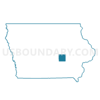
MALCOM TWP Voting District, Poweshiek County, Iowa
About
Outline

Summary
| Unique Area Identifier | 583306 |
| Name | MALCOM TWP Voting District |
| County | Poweshiek County |
| State | Iowa |
| Area (square miles) | 36.56 |
| Land Area (square miles) | 36.54 |
| Water Area (square miles) | 0.02 |
| % of Land Area | 99.95 |
| % of Water Area | 0.05 |
| Latitude of the Internal Point | 41.73856480 |
| Longtitude of the Internal Point | -92.60034450 |
Maps

Graphs
Select a template below for downloading or customizing gragh for MALCOM TWP Voting District, Poweshiek County, Iowa


Neighbors
Neighoring Voting District (by Name) Neighboring Voting District on the Map
- BEAR CREEK TWP Voting District, Poweshiek County, IA
- CHESTER TWP Voting District, Poweshiek County, IA
- GRANT TWP W/GRINNELL Voting District, Poweshiek County, IA
- MADISON TWP Voting District, Poweshiek County, IA
- PLEASANT TWP Voting District, Poweshiek County, IA
- SCOTT TWP Voting District, Poweshiek County, IA
- SHERIDAN TWP Voting District, Poweshiek County, IA
- WASHINGTON TWP Voting District, Poweshiek County, IA
Top 10 Neighboring County Subdivision (by Population) Neighboring County Subdivision on the Map
- Bear Creek township, Poweshiek County, IA (1,820)
- Madison township, Poweshiek County, IA (640)
- Malcom township, Poweshiek County, IA (580)
- Grant township, Poweshiek County, IA (522)
- Washington township, Poweshiek County, IA (451)
- Chester township, Poweshiek County, IA (302)
- Pleasant township, Poweshiek County, IA (289)
- Scott township, Poweshiek County, IA (257)
- Sheridan township, Poweshiek County, IA (248)
Top 10 Neighboring Place (by Population) Neighboring Place on the Map
Top 10 Neighboring Unified School District (by Population) Neighboring Unified School District on the Map
- Grinnell-Newburg Community School District, IA (12,151)
- Montezuma Community School District, IA (3,499)
- Brooklyn-Guernsey-Malcom Community School District, IA (3,347)
Top 10 Neighboring State Legislative District Lower Chamber (by Population) Neighboring State Legislative District Lower Chamber on the Map
Top 10 Neighboring State Legislative District Upper Chamber (by Population) Neighboring State Legislative District Upper Chamber on the Map
Top 10 Neighboring 111th Congressional District (by Population) Neighboring 111th Congressional District on the Map
Top 10 Neighboring Census Tract (by Population) Neighboring Census Tract on the Map
- Census Tract 3705, Poweshiek County, IA (3,309)
- Census Tract 3701, Poweshiek County, IA (3,157)
- Census Tract 3702, Poweshiek County, IA (3,048)